Trail Walking Bad Neuenahr-Ahrweiler - Ahrsteig Etappe 5 Rondwandeling 36km. - Photo
 flip96
flip96

User

© OpenStreetMap contributors
Length
Length
35 km
Max alt
Max alt
314 m
Uphill gradient
Uphill gradient
900 m
Km-Effort
Km-Effort  
47 km
Min alt
Min alt
110 m
Downhill gradient
Downhill gradient
887 m
Boucle
Boucle
Yes
Creation date :
2014-12-10 00:00:00.0
Updated on :
2014-12-10 00:00:00.0

(0 Reviews)

Walking
Walking
10h12
Difficulty : Difficult

Scan this QR Code to open this trail in the SityTrail application

FREE GPS app for hiking

Logo SityTrail SityTrail

IGN / Geographical institutes

Download SityTrail from the App Store Download SityTrail from Google Play

Logo SityTrail SityTrail World

The world is yours!

Download SityTrail from the App Store Download SityTrail from Google Play Download SityTrail on Huawei AppGallery

About

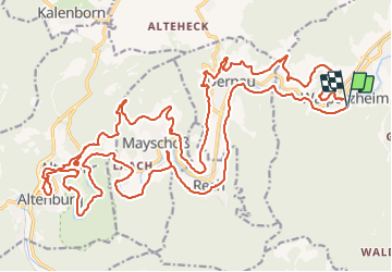
Trail Walking of 35 km to be discovered at Rhineland-Palatinate, Landkreis Ahrweiler, Bad Neuenahr-Ahrweiler. This trail is proposed by flip96.

Description

Ahrsteig etappe 5 rondwandeling.
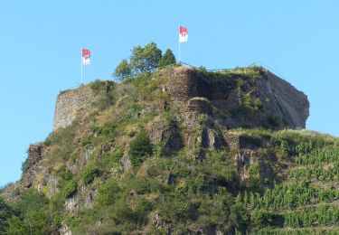
Via Rotweinwanderweg naar Altenburg (let op! op enkele punten afgeweken van route) en via Ahrsteig (A en AV1) terug naar Walporzheim.
Heel mooie route, maar zeer touristisch (druk met wandelaars, fietsers op wandelpaden en veel herrie van motoren).
Heenroute is flink klimmen, retour is nagenoeg vlak.
Opmerkingen? flip96@home.nl

Elevation profile

Positioning

Country:
Germany
Region :
Rhineland-Palatinate
Department/Province :
Landkreis Ahrweiler
Municipality :
Bad Neuenahr-Ahrweiler
Location:
Unknown
Start:(UTM)
363946 ; 5599221 (32U) N.

Trails nearby

Trail On foot Mayschoß - Mayschoß - Rundweg 3 - Photo
On foot
PRO

On foot

Easy
Mayschoß, Rhineland-Palatinate, Landkreis Ahrweiler, Germany
7.2 km | 11.9 km-effort
2h 41min
Yes
Trail On foot Mayschoß - Mayschoß - Rundweg 2 - Photo
On foot
PRO

On foot

Easy
Mayschoß, Rhineland-Palatinate, Landkreis Ahrweiler, Germany
5.8 km | 9.8 km-effort
2h 13min
Yes
Trail On foot Mayschoß - Mayschoß - Rundweg 1 - Photo
On foot
PRO

On foot

Easy
Mayschoß, Rhineland-Palatinate, Landkreis Ahrweiler, Germany
3.8 km | 6.2 km-effort
1h 24min
Yes
Trail On foot Bad Neuenahr-Ahrweiler - Eisenweg - Photo
On foot
PRO

On foot

Easy
Bad Neuenahr-Ahrweiler, Rhineland-Palatinate, Landkreis Ahrweiler, Germany
10.3 km | 13.9 km-effort
3h 9min
Yes
Trail On foot Bad Neuenahr-Ahrweiler - Weinbaulehrpfad - Photo
On foot
PRO

On foot

Easy
Bad Neuenahr-Ahrweiler, Rhineland-Palatinate, Landkreis Ahrweiler, Germany
6.7 km | 8.9 km-effort
2h 1min
Yes
Trail Cycle Bad Neuenahr-Ahrweiler - f-duitsland-oostelijke-vulkaaneifel - Photo
Cycle
gpstracks

Cycle

Very easy
Bad Neuenahr-Ahrweiler, Rhineland-Palatinate, Landkreis Ahrweiler, Germany
96 km | 125 km-effort
Unknown
Yes
Trail Walking Bad Neuenahr-Ahrweiler - Ahrsteig etappe 6 Rondwandeling 36km. - Photo
Walking
flip96

Walking

Difficult
Bad Neuenahr-Ahrweiler, Rhineland-Palatinate, Landkreis Ahrweiler, Germany
35 km | 49 km-effort
10h 18min
Yes


Close
My subscriptions